
How to use GPS to plan an overland trip
You probably use GPS for on-the-road navigation, but do you know how much more it can do? Find out how to use GPS to plan an overland trip, and learn about various ways this can help you (even months before your road trip begins)!
NOTE: This post is about general trip planning techniques, not limited to specific GPS apps, websites, or devices. Whatever your tool of choice, these same steps can be useful for you. I’ll cover my favorite tools in a separate post!
Here’s a look inside my road trip planning process, and some of the ways I use GPS during this phase.
Quick Navigation
Gathering possibilities for your overland trip
- I’m always on the lookout for cool ideas for future road trips, and I collect new places that I want to go. Even if I’m in the middle of a totally different trip on the other side of the world, I don’t want to let any ideas disappear.
- At first, these are just random notes and ideas. My favorite note-taking app (more about that another time) works on all my devices, so whether I’m on my laptop, phone or iPad, when I run across something I enter it in my notes, roughly organized by country.

- For instance, while I’m driving around the Yucatan Peninsula on a Mexico overland trip, I might run across…
- An article about cool things to do in Romania
- An intriguing Instagram post from Chile
- A place in Utah mentioned in a novel I’m reading
- A little-known beach a taxi driver in Merida told me about
- As a particular destination moves from my “someday list” to “serious road trip possibility”, it starts coming into focus. This is when I start collecting GPS coordinates for the places in my notes, and marking them on my map.
- In the above example, the taxi driver’s favorite beach is something nearby that I want to check out soon, so I’ll figure out where it is and mark its coordinates as a waypoint in my GPS system.
- If I’m thinking of heading to Chile before long, I’ll go through my notes for that country, and start laying out places I want to visit with GPS coordinates in my system.
- As I get further into road trip planning, I’m continually researching my upcoming destinations, actively seeking information from multiple sources of information. As a result, both my notes and my collection of GPS waypoints continue to grow. It’s an ever-evolving collection of overland trip data that expands as I find more information.
Getting a road trip overview with GPS
- As my collection of waypoints for a destination grows, I end up with a map of the area with waypoints mapped for everything I think could be important or interesting:
- Cities and towns that could be either destinations or hub spots
- World heritage sites
- National parks and other public lands
- Beaches and seashores
- Archaeological and historical sites
- Hiking trails and outdoor recreation areas
- Hot springs or cenotes
- Camping spots that sound interesting
- Other points of interest
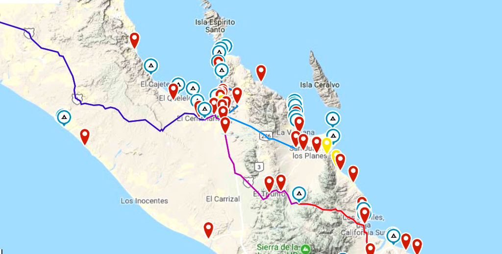
- This is my personal map, containing all the places that seem interesting and useful for me. It’s an essential tool in my road trip planning process, and it’s unique to me. Nobody else’s map would be quite the same.
- It’s much easier for me to get an overview of the driving trip I’m planning with this GPS map than looking at a generic printed or online map, because this is a selection of places that have specific meaning for me.
- The map makes it easy to see things like natural groupings of sites, and how things might fit together on a trip. For instance,
- It should be easy to fit in a stop at B, while I’m traveling from A to C
- Five of these places are all close together, while that other one is way off on its own. If I want to include it, it’s going to take more time, so I’ll need to decide how important it is.
- Using this map, I start figuring out ways to organize my trip, what places to include, how much time this would take, and which sites I might have to save for later. It’s all preliminary right now, but the trip plan is becoming clearer.
Figuring out driving routes and times
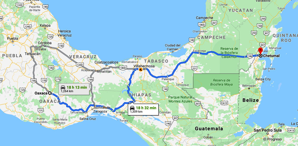
- When plotting routes for a trip, I usually start by using the waypoints I have saved, in conjunction with one of my mapping apps (Google Maps, Apple Maps, or Maps.me).
- Say I want to drive down the length of Baja, and I’m not sure how many days I’ll need just for driving time. I’ll choose some key places from my map, then plug the waypoints for either end into my mapping app to get a rough idea of distances and driving times.
- I always take driving times with a few grains of salt. I’ve run into situations, where things took MUCH longer than the mapping apps forecast. So I try to be conservative, planning for shorter days in case things take longer than anticipated.
- On one trip through Chiapas Mexico, Maps.me said the drive would take 2.5 hours, Apple said 3.5, Google said 4.5, and my actual driving time was 7.5 hours!
- Driving times may be suspect, but the mileages are usually pretty accurate. Combined with your vehicle’s gas mileage and the current local price of gas, this lets you estimate your fuel costs for the trip.
- My map also helps me find alternate stopping points. If a drive is taking longer than planned, it’s nice to know there’s another closer campsite, just a few miles off the road.
- You can also plot routes on your GPS, not just waypoints. Unlike getting a route with a mapping app, doing it on your GPS can give you precise control over the directions you take.
- Creating a route on your GPS app can also show you an elevation profile. This lets you compare different routes, to see if one is easier or steeper than another. This isn’t something I do often, but Zennie doesn’t have a lot of power for mountain driving, so sometimes this is important.
NOTE: At this point in the road trip planning process these aren’t decisions, just information. I usually leave specific travel decisions until the day itself. Then I can see how I feel, what the weather’s like, and adjust for any new information I’ve gotten (like road conditions or a cool hike a fellow camper told me about).
Overlanding with GPS – Campsites and hotels
- When I’m looking into places to stay on my driving trip, I also create GPS waypoints for my short list of campgrounds and hotels.
- Marking these locations on my trip planning GPS map lets me easily see where they are in relation to other things I’m looking for. Can you walk to the museum from the hotel? Is the campsite 2 blocks or 12 from the beach?
- For hotels, a GPS app with various map layers available will let you zoom in on both street and satellite views. This can give you a better idea of what the property, neighborhood and streets are like.
- Some hotels will let you “camp” in their parking lot. This can be pretty convenient, but I drive an oversize vehicle that won’t fit in a cramped little parking area. Zooming in on satellite view lets me check out the parking situation in advance.
- On a lot of overland trips, finding great campsites can make a huge difference in how enjoyable your trip is. Your GPS app can help with this, too.
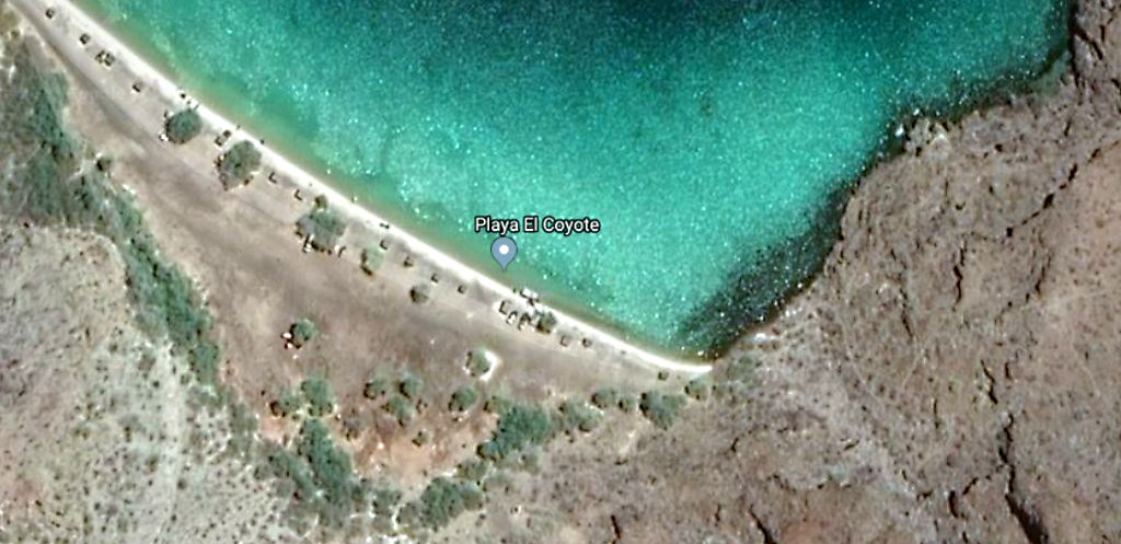
- Zooming in on the satellite view of a campground is enlightening. You can usually see how the entry to the site looks, and whether the spots are big or small, crowded or sparse, sunny or shaded. Are there buildings, large trees, paved sites, beach access, or empty space for boondocking? Satellite imagery can tell you so much.
- If you’re planning to boondock on public land (perhaps finding campsites with a Motor Vehicle Use Map), you can sometimes spot clearings and potential campsites this way, too. You can’t see how rough that dirt road really is, but it can yield ideas for further investigation.
- I always try to include waypoints for alternate campsites that are closer or farther than my primary target. Sometimes the driving goes slowly or I get a late start, and want to stop sooner. Other times the campground I’m aiming for could be full, closed, or doesn’t look as good as I hoped, so I may continue on to another campground.
Digging into driving trip details
Sometimes there’s nothing like a satellite image on your GPS app to clarify a situation. You’ve got all your existing waypoints marked on the GPS map, and can add new points for navigation based on your discoveries. Here are a few situations where I’ve made use of this.
- Missing roads. On my Sonora Sojourn Mexico road trip, I wanted to drive down the coast of Sonora. I’d read people talking about taking this route, but none of my paper maps showed a road here. Fortunately satellite view confirmed there’s a nice looking paved road, even though most maps didn’t know about it.
- Type of road. A satellite image won’t tell you how many potholes there are, but you can usually tell whether a road is wide or narrow, paved or dirt. If it’s a road that starts out paved then turns to dirt, this can give you an idea how far you’ll have to drive on both.
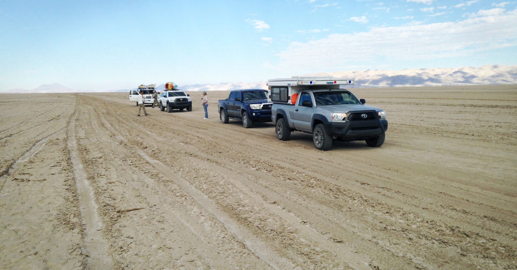
- Make your own road. Sometimes there isn’t any road. For instance, in northern Baja, Mexico, you can (depending on season and weather) drive across the dry lake bed of Laguna Salada. Some maps just show this as a large lake, like you’re driving straight into the water. Using GPS, I could plot a route across the lake to our destination and input important waypoints where we needed to turn into the canyon we wanted. Having this all marked on GPS beforehand gave me much more confidence when facing an empty, dusty lake bed in person.
- Too many roads. Sometimes you may run into a desert or beach location where there’s a network of dirt roads winding here and there, with no clear route. You can’t know their various road conditions until you see them in person, but at least you can figure out some alternatives, and have your start and end points clearly marked (e.g. the exit from highway and your desired campsite by the beach).
You’re SO well prepared for your overland trip!
So now you know some of the ways I’ve learned how to use GPS to plan an overland trip.
Once you know how to use GPS to plan a driving trip, this trip planning process can give you a better understanding of where you’re headed, what the driving will be like, and what you’ll find when I get there. You’ve also got a selection of places to stay, and an idea of what they will offer you.

I have to admit I’m not always totally prepared like this for every overland trip! 😉 I often hit the road with only a fraction of this done. But I do as much advance prep work as time permits, and keep adding to it as I go.
Having some things figured out in advance (with my trusty GPS app) lets me fit more good places into the same limited time, and lets me relax more because I know I’ve got lots of information at my fingertips. Navigation on the road is easier, and I’ve got good places to stay figured out – both a primary target and some backups.
But the decision making is still left to the day itself, and there’s plenty of room for spontaneity. If I run across a sign pointing to a cenote in some little town, or a fellow camper tells me about nearby hot springs, I can easily stop for a delightful swim.
Questions? Comments?
Do you have questions about any of this? Are you a fan of road trip planning with GPS? If so, how do you use GPS to plan a driving trip? Please share any questions, tips, or techniques you find useful in the Reply section below. Thanks for sharing, and happy travels!
PHOTO CREDITS: Map – Paula May (Unsplash), Notes – Oxana V (Unsplash), Others – Deanna Keahey

Hi! I’m Deanna, creator of Uphill Zen. I’m currently yondering around somewhere, often with my Toyota motorhome, Zennie. What makes my heart sing is travel, adventure, and the wonders of nature. Sharing that joyous spirit is what this is all about.

Site search
Places
Categories
Popular posts

Discover the magic and mystery
This stunning new book takes you to the Yucatan Peninsula, an exotic and fascinating land.
- Explore ancient Mayan cities lost in the jungle
- Swim below the stalactites in exquisite cenotes
- View a thousand flamboyant flamingos
- Experience life in a Maya village
- See the inner workings of historic haciendas
- Find a tranquil beach to call your own
Hundreds of vivid color photos bring the magic of the Yucatan to life, and adventurous souls will find all the “how to” details you need to make each experience your own.

Leave a Reply